Kythnos sailing holidays
The island of Kythnos - Κύθνος lies south-south-east of Kea and is a rocky and mostly barren island of karstic limestone, that is usually covered in an abundance of colourful flowers in the early months of the sailing season.
The coast is much indented – with many beautiful anchorages and ports – and for the most part falls steeply down to the sea. The inhabitants live by farming and fishing, while in antiquity iron was mined on the island.
Highlights are the villages of Chora and Chorio, Mericha and Loutra ports and the splendid anchorages of Sandbar bay, Stefanos bay (also to visit Chorio), Flampouria and Kanala bay, see Ports and anchorages below.
History of Kythnos
Towards the north, high above the western shores, is the hidden gem of the medieval (7th c.) Kastro Orias - Κάστρο της Ωριάς / Οριάς: Castle of the fair Maiden, that provided long-term safety for ±100 buildings and ±500 inhabitants. This lasted till 1537 when the Turk Barbarossa raided the island, after which the survivors founded a new capital at the current Chora.
Like the medieval castle, the two charming inland villages, Chora (Kythnos capital) and the lively little Dryopis or Dryopia or Chorio, can best be visited by scooters / bicycles.
Dryopis preserves the name of the original settlers on the island, after the Dryopes from Evvia, who were later driven out by the Ionians. Around the village are numerous windmills and the Katafaki cave, which served in the the past as a refuge.
Although Kythnos never played any important part in history, it can take pride in having one of the oldes settlements in Greece; Mesolithic Maroulas near Loutra.
The earliest inhabitants in written history were the pre-Hellenic Carians – allied to or under the dominion of the Minoans – who eventually abondoned the island and settled in south-west Turkey, now a popular sailing venue called the Carian coast.
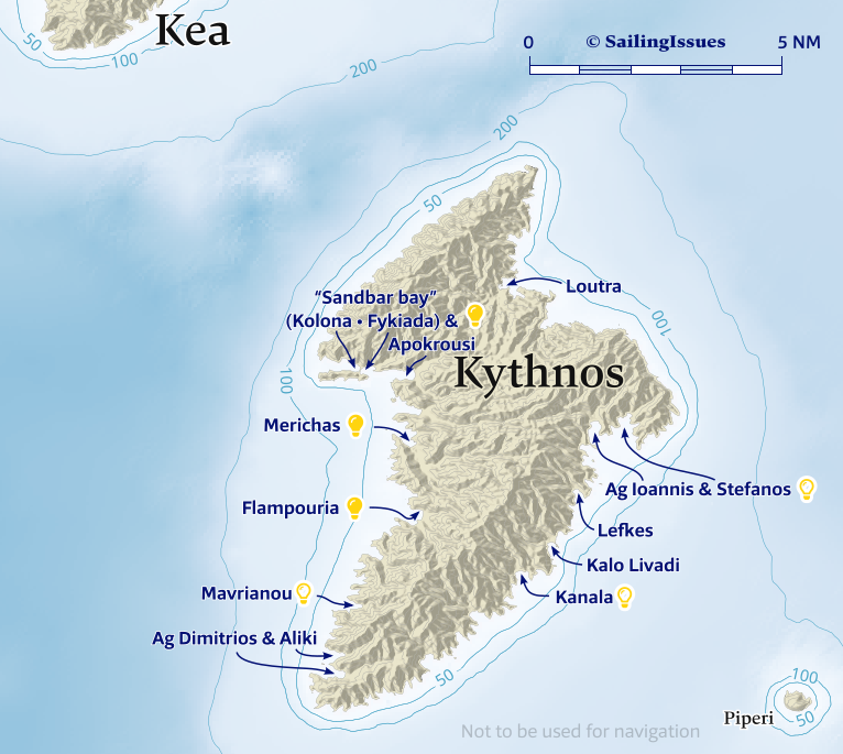
Kythnos ports & anchorages
Clockwise ↻
- Merichas
- Loutra
- Ag Ioannis & Stefanos
- Lefkes
- Kalo Livadi
- Kanala
- Ag Dimitrios & Aliki
- Mavrianou
- Flampouria
The Athens' Alimos Marina, and the island of Paros are the most convenient yacht charter bases to start your sailing holiday and explore Kythnos and the other northern Cyclades islands.
Ports / anchorages are clickable . signifies a highly recommended venue, and a truly must-see venue; see other icons.

Merichas
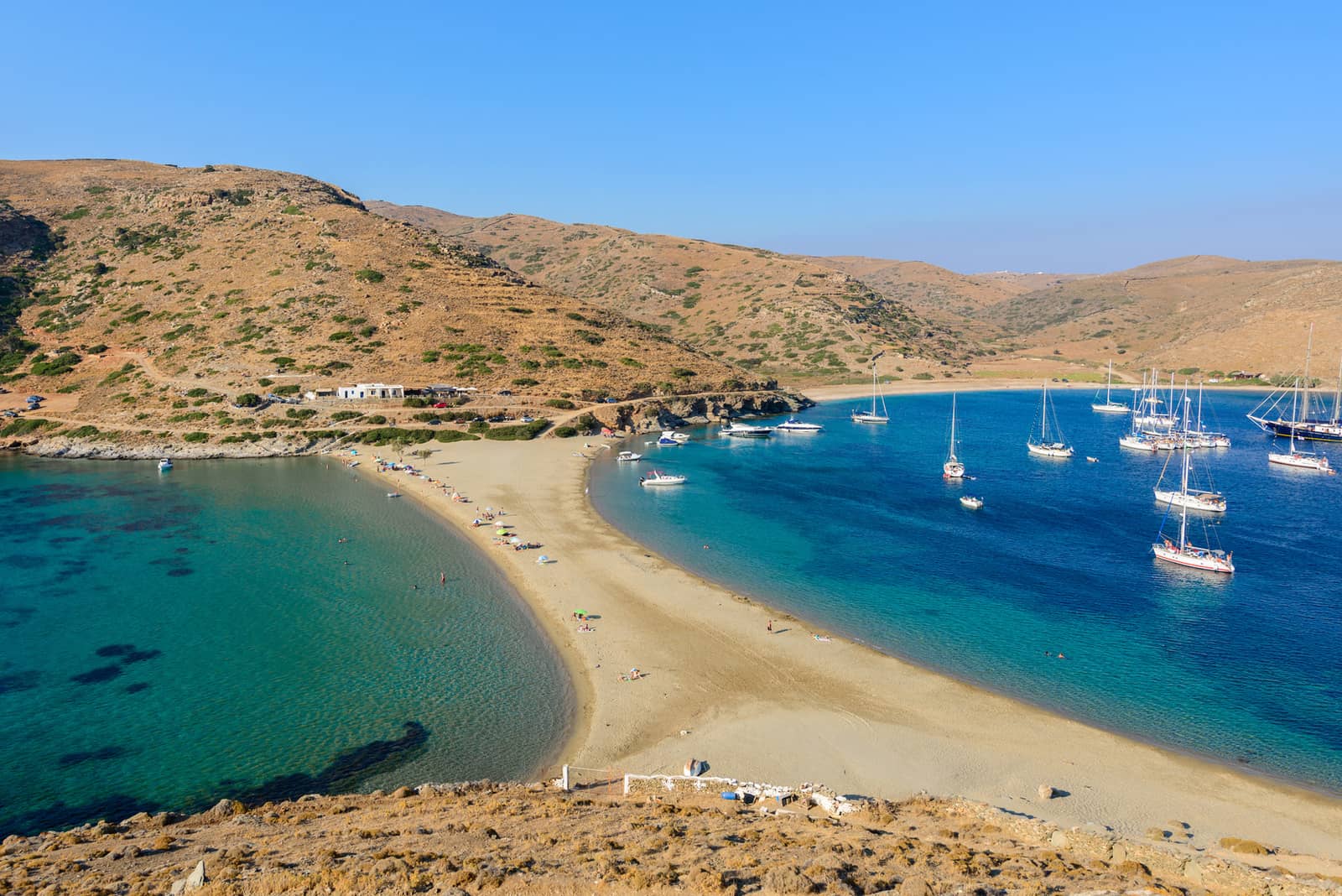
To the north of the small (ferry) port of Mérichas - Μέριχας, on a high crag above the bays of Apokrousi and Episkopi, are the ruins of the Kythnos' former capital, Vryokastro (Evraiokastro).
Also to the north – on the rocky peninsular island in Sandbar bay originally connected properly with the mainland – traces of the agora and of a number of tombs in the surrounding area can still be identified, together with ruins of walls, temple foundations and three caves for water collection.
Sandbar bay features two anchorages: Kolona - Κολώνα and Fykiada - Φυκιάδα, plus a 40°C water fountain
To the east is the anchorage of Apokrousi (Apokreiosi) - Απόκριση.
Loutra
Loutrá - Λουτρά on the north-east nowadays features a port providing the best protection from the Meltemi on the island. The mineral baths after which the port took its name, are unfortunately no longer in use (we had an abysmal but hilarious spa treatment there being non-stop verbally abused by the bath-lady-in-chief).
These mineral springs were already frequented in Roman times and can still be seen as (covered) streams that flow towards the port. During the period of Venetian rule the island was known, after the springs, as Thermiá (Italian: Fermenia). The now dilapidated bathing establishment was built in the reign of Otto of Bavaria, first King of Greece.
The rectangular bay of Ayia Irini / Eiríni - Αγία Ειρήνη is the alternative when in summer all berths are filled in Loutra port. You can take a line ashore. Lat Long
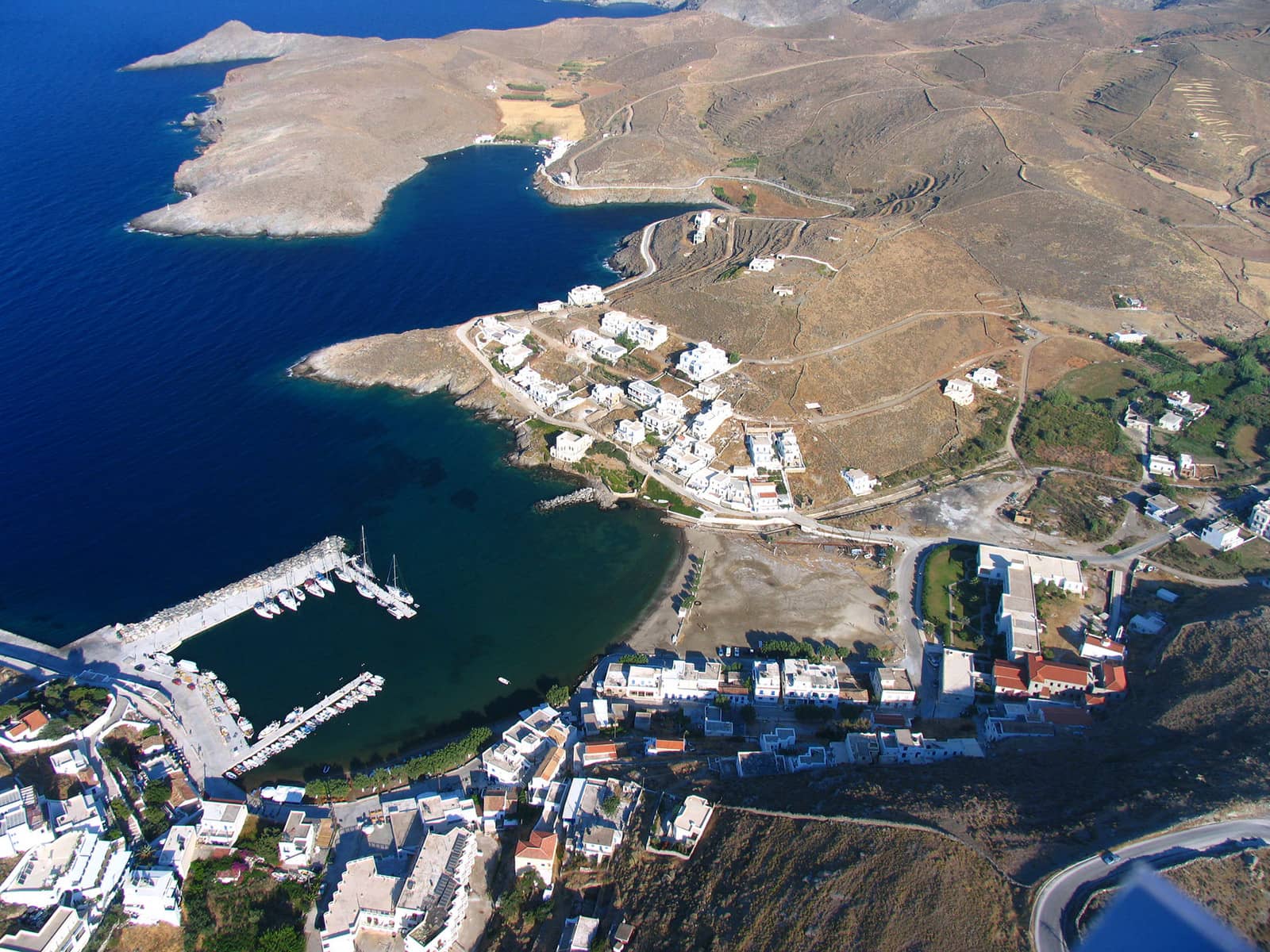
The larger Ay Irini bay near the top of the image also provides excellent shelter.
Ag Ioannis & Stefanos
South of Kythnos' east Cape Ioannis there are a multitude of delightful cerulean bays. Note that the GWP chartlet is outdated and not sufficient, instead use Eagleray, Garmin or C-Map. Moreover, reef Zogkakia Lat Long is a serious hazard ; an approach from SE – E is recommended.
- Ágios Ioánnis - Άγιος Ιωάννης bay: anchor close to the bright white Church of Ag Theologos Ioannis; sometimes mediocre holding due to rocks; gusts from NE; more desolate and marvellous, Lat Long.
- Ágios Stéfanos - Άγιος Στέφανος: gusts from NWN; the wreck near the 12 m contour line has a minimum depth of 16, be sure to take a line ashore, see how to do this, if the wreck is within your swing circle; tavernas ashore; the best holding due to a more muddy seabed, Lat Long.
- Lousa / Aosa: most all-round shelter and is only open to E – SE winds; quite sequestered, Lat Long.


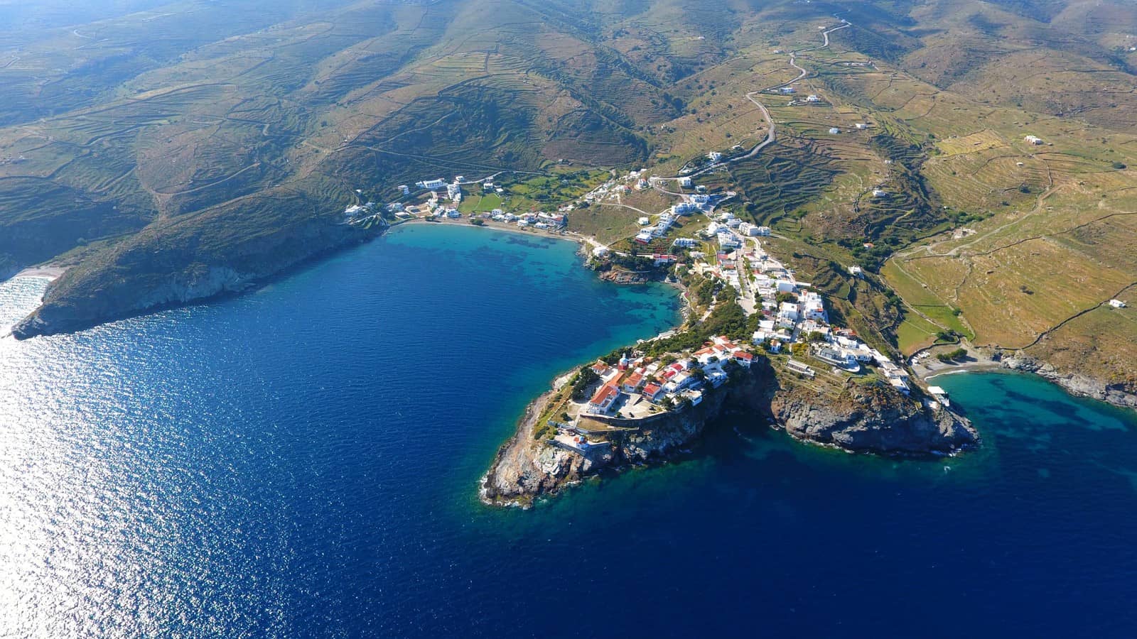
Lefkes
The Lefkés - Λευκές cove and beach is not correctly positioned on C-Map, GWP and Garmin and is much closer to Ayios Ioannis. Onshore you will find a beach with Tamarisk trees and a decent taverna; the area has its charms with low undulating hills instead of a “ravine” as mentioned in GWP. On the north side an overhanging metal crane marks this bay as one of Kythnos' former loading ports. Eagleray publications show the correct location of Lefkes, Lat Long.
The tiny inlet of Liotrivi - Λιοτρίβι directly south Lat Long is only suitable as a lunch anchorage.
Kalo Livadi
The bay of Kaló Livádi - Καλό Λιβάδι is a bit more developed, Lat Long. A reported wreck (18) approx. near the 5 m depth contour; we haven't used this anchorage.
Kanala
In the south-east of the island is the bay of Kanála - Κανάλα, with the Church of the Panagia Kanala, which holds a miraculously retrieved icon.
Panagia Kanala - Παναγιά Κανάλα is the patron saint of Kythnos island and local lore has it that his icon was found in a canal. The marvel is celebrated extensively on 15 August and 8 September with dancing and dining.
The engaging anchorage – drop your anchor just west Lat Long of the minute pier – provides sufficient safety in northerlies but is open to the south. The small promotory has become rather developed but in tasteful cubic, white and blue fashion, with lush and green surroundings.
Note the reef roughly 0.3 NM south of Cape Kanala.
Ag Dimitrios & Aliki
Ágios Dimítrios - Άγιος Δημήτριος bay and adjacent Alikí / Alykí - Αλυκή bay are separated by a narrow headland and the isle of Nisopoulo; charted depth of the channel is 2 m.
Water, provisions and tavernas ashore.
Ag Dimitrios is open to SW – NW winds and suitable in Meltemi conditions, whereas Alyki is open to all westerlies, Lat Long.
Pandemic
From Ancient Greek πάνδημος (pándēmos, “of or belonging to all the people, public”) + English -ic (suffix forming adjectives “of or pertaining to”) and πάνδημος is derived from παν- (pan-, “all, every”) + δῆμος (dêmos, “the common people; free citizens”), read on…
Mavrianou
Mavriánou - Μαυριάνου is a secure anchorage (see my Mediterranean mooring and anchoring course) in sand / weeds; reasonably off the beaten track, short beach (called “Stifo”) distinguished by a single cluster of Tamarisk trees, Lat Long.
Flampouria
The beach of Flampoúria - Φλαμπούρια bay revolves around the Church of Panagia Flampouriani: festivities on 22 August when the church square is filled with long tables and the church itself is adorned with lights.
Like Mavrianou bay excellent holding and suitable in N – NE Meltemi storms; taverna ashore;
anchor in 5 m at the north end of the beach, Lat Long.