Compass navigation
Marine compass
In China compasses have been in use since the Han dynasty (2nd century BCE to 2nd century CE) when they were referred to as “south-pointers”. However, at first these magnets were only employed for geomancy much like Feng Shui.
Eventually, during the Sung dynasty (1000 CE) many trading ships were then able to sail as far as Saudi Arabia applying compasses for actual marine navigation. As a direct result, between 1405 and 1433, Emperor Chu Ti's Treasure Fleet of the Dragon Throne ruled the entire South Pacific and the Indian Ocean; a territory that ranges from Korea and Japan to the Eastern coast of Africa.
At this time Western mariners were still rather incognizant of the navigational application of the magnet. The first treatise on the magnet itself was written by Petrus Peregrinus de Maricourt: “De Magnete” (1269). And though its nautical use was already mentioned in 1187 by the English monk Alexander Neckham, the use onboard only came about around the 13th and 14th century in the Mediterranean Sea.
In 1545 Pedro de Medina (Sevilla 1493-1567) wrote the Spanish standard work “Arte de Navegar” on marine compass navigation. This masterpiece was first translated in Dutch (1580) and was – O Irony – put into practice by Jacob van Heemskerk when the Dutch destroyed the Spanish fleet near Gibraltar in 1607. A drawback, obviously, was Van Heemskerk's own death during this victory.
Magnetic Variation
In the fin-de-siècle of the 16th century mariners believed that the magnetic north pole coincided with the geographic north pole. Any suggestion otherwise had been denied by Pedro de Medina.
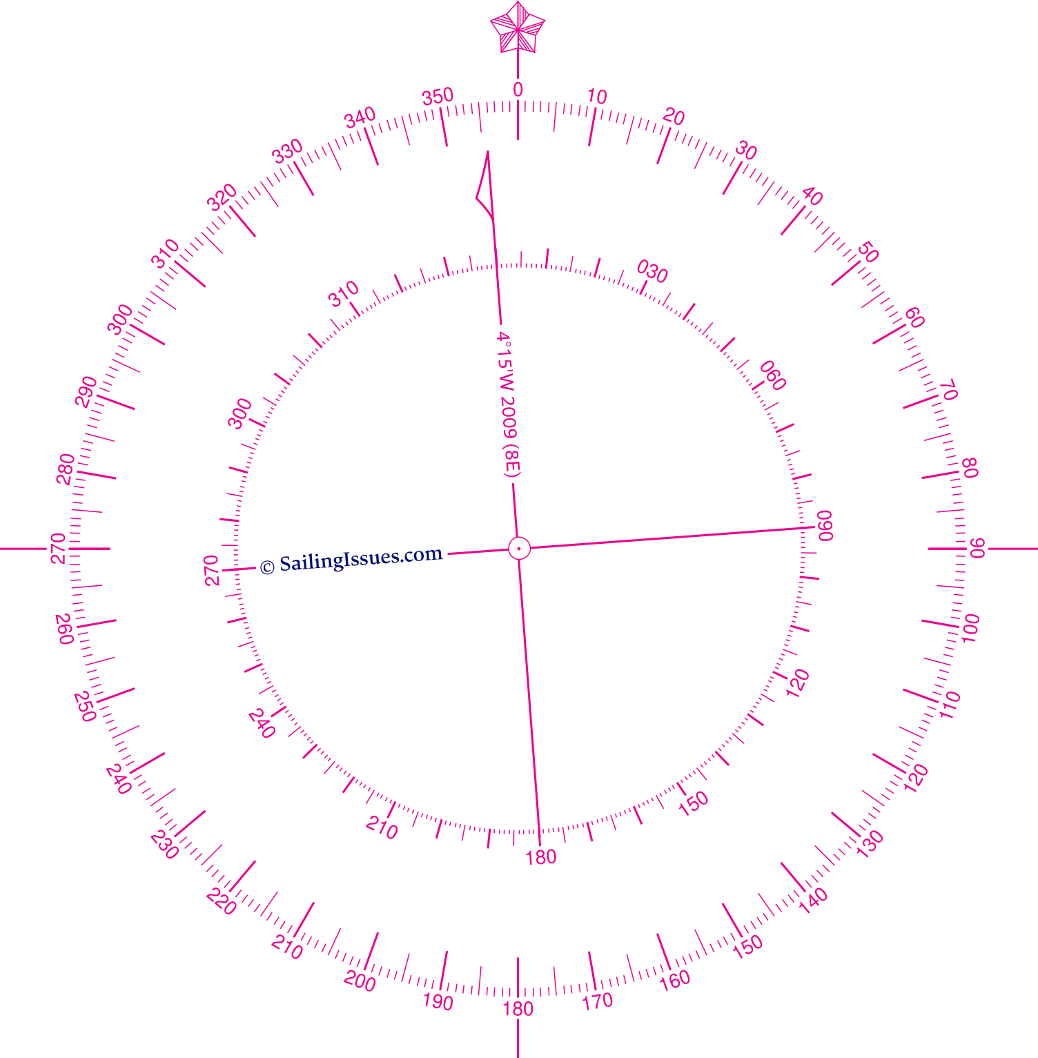
The magnetic variation is shown via the inner rose and along the arrow: 4° 15' W 2009 (8' E).
Click to find out what this means.
Magnetic observations made by explorers in subsequent decades showed however that these suggestions were true.
But it took until the early nineteenth century, to pinpoint the magnetic north pole somewhere in Arctic Canada (78° N 104° W). From then on the angle between the true North and the Magnetic North could be precisely corrected for. This correction angle is called magnetic variation or magnetic declination.
It is believed that the Earth's magnetic field is produced by electrical currents that originate in the hot, liquid, outer core of the rotating Earth. The flow of electric currents in this core is continually changing, so the magnetic field produced by those currents also changes. This means that at the surface of the earth, both the strength and direction of the magnetic field will vary over the years. This gradual change is called the secular variation of the magnetic field. Therefore, the encountered magnetic variation not only changes with location, but also varies over time.
The correction for magnetic variation for your location is shown on the nearest nautical chart's compass rosenautical chart's compass rose. In this example we find a variation of 4° 15' W in 2009, with an indicated annual correction of 0° 08' E. Hence, in 2011 this variation is estimated to be 3° 59' (almost 4° West), and for 2020 the estimate is 2° 47' W
This means that if we sail 90° on the chart i.e. the “true course”, the steering compass would read 94° in 2009, and almost 93° in 2020.
Note that the “true course” is often shown as COG “Course Over Ground” or CMG “Course Made Good” on your GPS plotter.
Another example: let's say the compass rose on the nautical chart gives a variation of 2° 50' E in 2019, with a correction of 0° 04' E per year. In 2021 this variation is estimated to be 2° 58', nearly 3° East; if we sail 90° on the chart, the steering compass would read 87°.
A paper or digitized nautical chart can feature multiple compass roses: use the nearest one to obtain the magnetic variation.
Correcting for variation
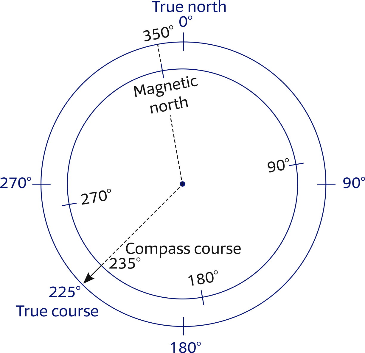
The overlayed compass roses aboveon the right illustrate the difference between true North and magnetic North when the magnetic variation “var” is 10° West.
From the image we find: tc = cc + var
in which “cc” and “tc” stand for “compass course” and “true course”, respectively.
To convert a true course into a compass course we need first assign a “ − ” to a Western and a “ + ” to an Eastern variation. Note that this makes sense because of the clockwise ↻ direction of the compass rose.
Here, the inner circle is turned 10° anticlockwise, hence −10°
Now, use the same but re-written equation:
cc = tc − var
235° = 225° − (−10°)
So, to sail a true course of 225°, the helmsman has to steer a compass course of 235°.
To convert a compass course into a true course we can use the original equation. If we have steered a compass course of 200°, we have to plot a true course of 203° in the chart if the variation is 3° East or a true course of 190° if the variation is 10° West
Magnetic deviation
Magnetic deviation is the second commonly correctable error – this time within the ship – which is caused by magnetic forces brought on by pieces of metal, such as an engine or an anchor. Moreover, cockpit plotters and other electric equipment or wiring – if too close to the compass – can also introduce a compass error.
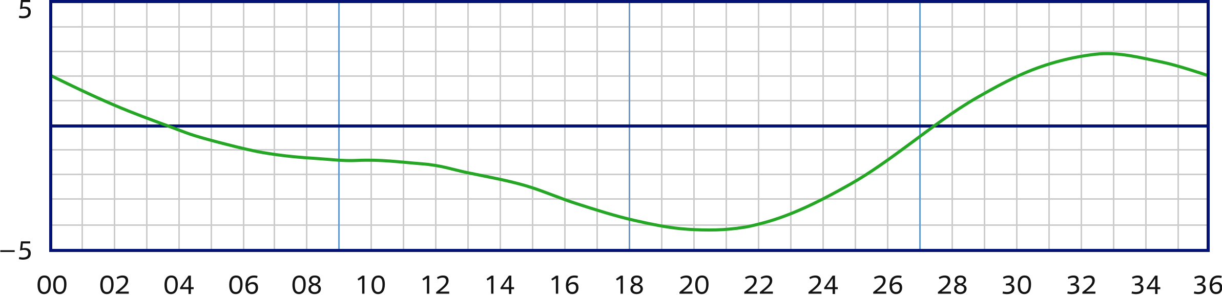
Pertinently, the deviation varies with the ship's heading (HDG), the angle of the yacht's centre line with the true North, resulting in a deviation table / chart as shown below.
|
The vertical axis states the correction “dev” in degrees West or East, where East is again positive.
The horizontal axis states the ship's heading “cc” in degrees divided by ten. Thus, when steering a compass course of 220°, the deviation will be 4° W.
Note, that on most modern sailing yachts the deviation will be less than ±3°.
When a steering compass is newly installed it often shows larger deviations than this and will require compensation by carefully placing small magnets around the compass. It is the remaining error that is shown in your deviation table.
You should check the table every now and then by placing the yacht in the line of a pair of leading lightsleading lights and turning her 360 degrees, a time-honoured method known as “swinging the compass”.
Conversely, a handheld compass does not have a deviation table, ideally bearings should be taken as far from metal and electrical wiring as possible.
Correcting for both deviation and variation
Converting a compass course into a true course, we can still use our equation but we need to add the correction for deviation:
cc + var + dev = tc
- Example 1: we sail a compass course of 330°, with a corresponding deviation of +3°, see table, and from the nautical chart we find that at our location the variation is +3°;
330° cc + 3° var + 3° dev = ?° tc
giving a true course of 336° which we can plot in the chart. - Example 2: we change our compass course to 220°, the deviation is −4° (table) and the variation is still +3° (chart);
220° cc + 3° var + −4° dev = ?° tc
giving a true course of 219°. - Example 3: after sailing extensively our compass course is still 220°, therefore the deviation is still −4° (table), but since we are at a new location the nautical chart specifies a variation of −10°;
220° cc + −10° var + −4° dev = ?° tc
giving a true course of 206°.
Converting a true course into a compass course – finding a Course To Steer (CTS) – is a little less straight forward, but it is still done with the same equation.
- Example 4: the true course drawn in the chart is 305° and the local variation is +3° (found in the nautical chart), yet we don't know the deviation;
?° cc + 3° var + ?° dev = 305° tc
Luckily, we can rewrite this so this reads:
cc + dev = 305° tc − + 3° var = 302°
In plain English: the difference between the true course and the variation (305 − + 3) = 302 should also be the summation of the compass course and the deviation. So, we can tell our helms person to steer 300°, since with a cc of 300° we have a deviation of +2°,as can be deduced from the deviation table. - Example 5: the true course from the chart is 150° and we have a Western variation of 7 degrees (−7°). We will use the rewritten equation to get:
150° tc − − 7° var = cc + dev = 157°
From the deviation table we find a compass course of 160° with a deviation of −3°.
Voilà!
Lateron in this course we will consider more comprehensively the CTS and compensate for leewayCTS and compensate for leeway.
Magnetic course
The magnetic course (mc) is the course after magnetic variation has been considered, but without compensation for magnetic deviation. This means that we are dealing with the rewritten equation from above:
tc − var = cc + dev = mc.
Magnetic courses are used for three reasons:
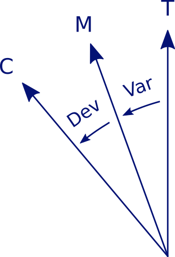
Figure 3.4 –
Three types of North:
True, Magnetic,Compass.
- To convert a true course into a compass course like we saw in the last paragraph.
- On vessels with more than one steering compass, also more deviation tables are in use; hence only a magnetic or true course is plotted in the chart.
- Bearings taken with a handheld compass often don't require a correction for deviation, and are therefore useful to plot in the chart as magnetic courses.
Note, that the actual course lines the navigator draws (plots) in the chart are always true courses, unless labeled as mc or cc.
In chapter 4chapter 4
we will be plotting courses in the chart.
To summarise, we have three types of “North” (true, magnetic and compass North), correspondingly we have three types of courses: tc, mc and cc. All these are related by deviation and variation.
Glossary
- Variation: the angle between the magnetic north pole and the geographic north pole. Also called the magnetic declination
- Secular variation: the change of magnetic declination in time with respect to both strength and direction of the earth's magnetic field; view these declination / variation maps with isogonic lines world – interactive and historical declination and an animated-in-time GIF.
- West “ − ”, East “ + ”: West variations / declinations as well as West deviations are designated with a negative sign by convention due to the compass card's clockwise ↻ direction.
- Deviation: the compass error caused by electrical currents and / or metal objects.
- Deviation table: a table containing deviations in degrees versus the ship's heading (compass course) in degrees; usually plotted in a graph / card.
- True course: the course corrected for compass errors and plotted in the chart, tc and is equal to Course Over Ground (COG) or Course Made Good (CMG)
- Compass course: (cc or CTS) the course which is corrected for both variation and deviation.
- Magnetic course: (mc) the course which is only corrected for variation.
- cc + var + dev = tc: this equation shows the connection between the compass course, its errors and the true course. It can also be read as: tc − var = cc + dev.
See the next chapter…
Also you can download the exercises + answers PDF ![]()