Zakynthos sailing holidays
Zakynthos - Ζάκυνθος (Italian Zante), besides Kythira the southernmost island of the Ionian Islands, lies off the west coast of the Peloponnese.
The western half of the island is occupied by a karstic plateau rising to 758 m, the eastern half by a fertile and intensively cultivated alluvial plain with a luxuriant growth of vegetation.
With its beautiful scenery, convenient airport and excellent bathing beaches, Zakynthos is an extremely popular holiday island, with tripper boats, jet skis, and banana rides even in and around the anchorages.

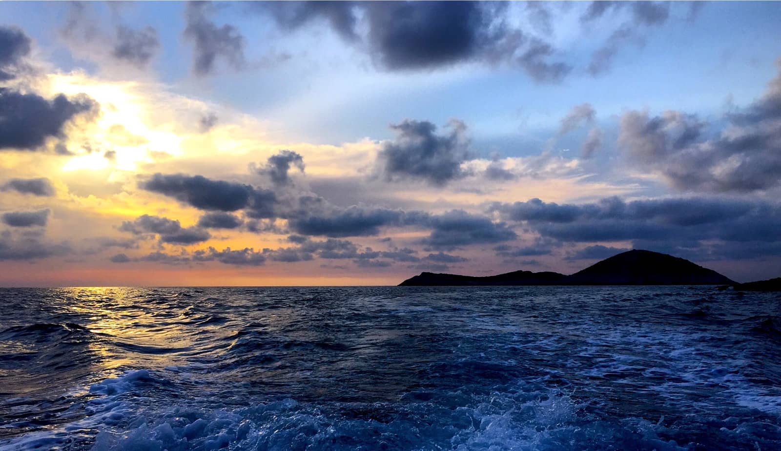
The bay of Lagana with Cape Geraki in the foreground, the islets of Pelouzo and Marathonisi (vague) in the middle and Cape Marathia in the distance left. Hi-res image
History
The island has been known since the time of Homer by the name it still bears, said to be derived from the wild hyacinth (Hyacinthus orientalis L.). The name, like all similar names ending in -nthos, is pre-Mycenaean or Pelasgian in origin.
In Greek mythology the island was said to be named after Zakynthos, the son of the legendary Arcadian chief Dardanus.
Iridescence
The word iridescence is derived from the Greek word ἶρις îris, meaning rainbow. Iris in turn derives from the goddess Iris of Greek mythology, who is the personification of the rainbow, read on…
Settled at an early period by Achaeans and Arcadians, it soon developed into a trading and seafaring town the influence of which extended as far as the Iberian peninsula, where it founded the colony of Zakantha, later known as Saguntum.
In 455 BCE the Athenian admiral Tolmides made the island a dependency of Athens.
After the Peloponnesian War it became a member of the Attic maritime league.
In 217 BCE Zakynthos was conquered by the Macedonians, in 191 BCE by the Romans.
After being devatasted by the Vandals it was captured by the Normans, and later was ruled by Frankish dynasts. It was occupied by the Turks in 1479 but recovered two years later by the Venetians, who held it until 1797. Thereafter, it shared the fortunes of the other Ionian islands.
- All Greek islands
- Ionian overview
- Corfu, North Ionian
- Lefkas, Meganisi
- Kefalonia, Ithaca
- Zakynthos
- Sailing itineraries Ionian islands
From its long period of association with Venice the island has preserved an Italian and Venetian stamp. As a result of the devastations suffered in the course of an eventful history and of severe earthquakes damage – particularly in 1515 and 1953 – Zakynthos has preserved few old buildings.
Zakynthos island ports & anchorages
Clockwise ↻
- Zakynthos port
- Porto Roma
- National Marine Park of Zakynthos
- Vromis • Porto Vromi
- Navagio
- Ag Nikolaos
- Makris Gialos
- Xigia
- Alikanas
- Sea caves

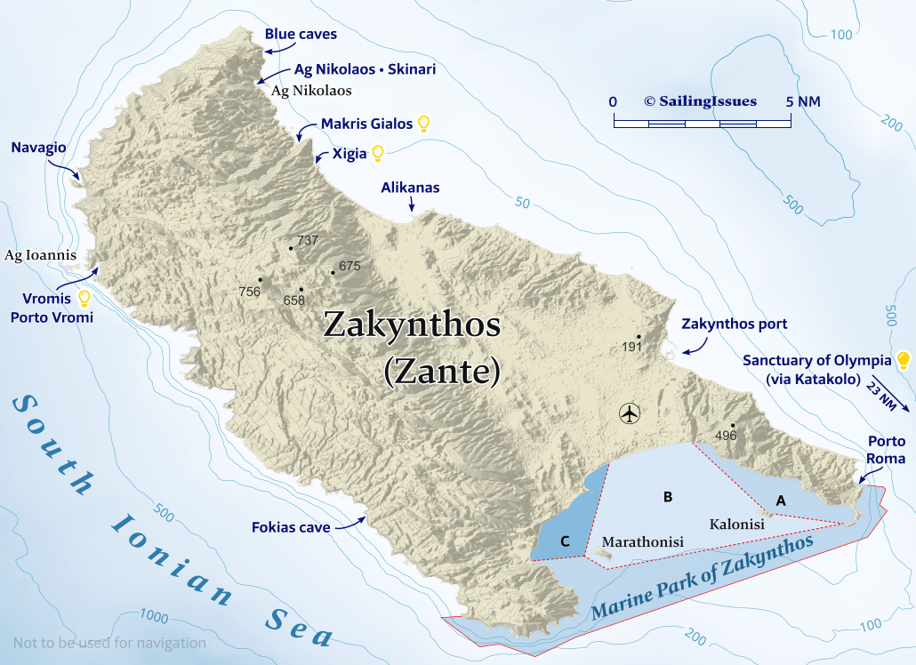
Ports / anchorages are clickable .
British Admiralty Chart 203, 189. signifies a highly recommended venue, and a truly must-see venue; see other icons.
On the approach mind the Dimitris reef directly east of the green harbour light. Once in port, go stern-to the waterfront or the north breakwater or the pier that protudes from it.
The river Charalampos delivers sand / mud to the bay: the south-western part of the port is often too shallow.
Like the “marina” facilities, the plans for a cruise ship quay and a commercial port to the south have yet to materialize, the breakwaters are already disintegrating. The south basin meanwhile is used by tripper boats, charter fleets and ferries dock on the north side.
Strong S – SE winds, only probable in winter and early spring, mean you should leave the main port, e.g. to the south basin.
Prevailing wind is NW, sometimes a violent NE, in which case the north breakwater has the preferred berths; mud and good holding; avoid going along-side due to waves created by several lawless tourist boat skippers, keep your stern well clear, and place your fenders low since the structure is rather low.
Price should be about €1 per meter per day, payable at the pink building (Port Authority). However, prices negotiated with the men-in-blue-T-shirts from YCZ are much higher, also look out for a certain water truck and a diesel truck: reports of rip-offs.
Water on the quay can be too salty, check first before filling your tanks; toilets and showers were closed; no facilities worth mentioning; plenty of complains about the Yachting Club Zakynthos (YCZ) overcharging and intimidating visiting yachts.
So, work directly with the Port Office Authority located near the ferry dock in the pink building, top floor, opening hours 08:00 – 15:00 Mon – Fri, key for electricity available with a deposit.
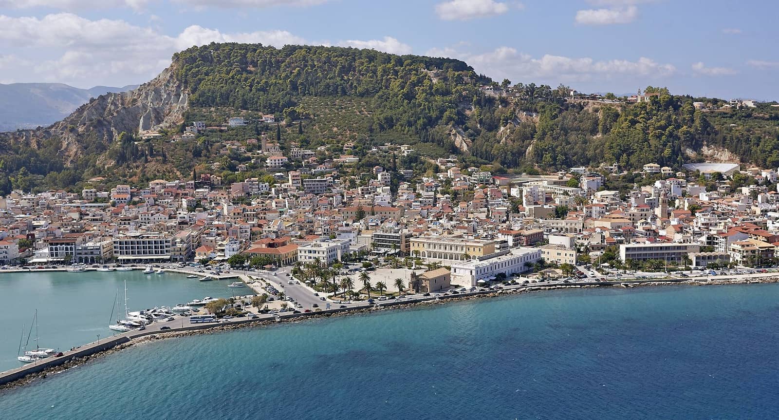
Due to the 1953 devastations as well as the surplus of superficial beach tourists, Zakynthos town / port is more practical than endearing.
Dine at “Ammos Taverna” overlooking the Northern basin.
Explore the refurbished Venetian Castle.
The Marine Park offers guided tours.
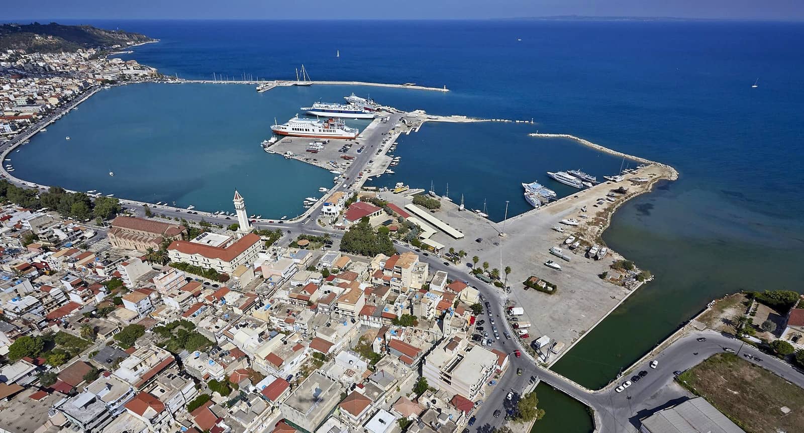

Note the “new” 2016 pier for visiting yachts protruding from the Northern breakwater (left).
The white tall pole on the piers end is very conspicuous. Hi-res image
The splendid Sanctuary of Olympia – located on the Peloponese – is best explored from the secluded Katakolon port, a 23 NM sail to the south-east. Alternatively there are organized day-trips from Zakynthos via regular ferries to Kyllini / Cyllene port.
Porto Roma
Porto Porto Roma - Πόρτο Ρόμα is heralded by many guides as an idyllic anchorage suitable for calm weather Lat Long, but we found that it is overcrowded with blaring beach tourists with several resorts appropriating the area. The bay is adjacent to the NE boundary of the Marine Park; nice Nikos restaurant ashore; reasonable shelter against the prevailing NW, otherwise exposed; good holding if on sand; Banana rides with screaming guests from the nearby hotel, water-ski & jet-ski maniacs boosted by Vodka Red Bull; Zakynthos Sea Turtle Rescue & Information Center 20 min. walk.
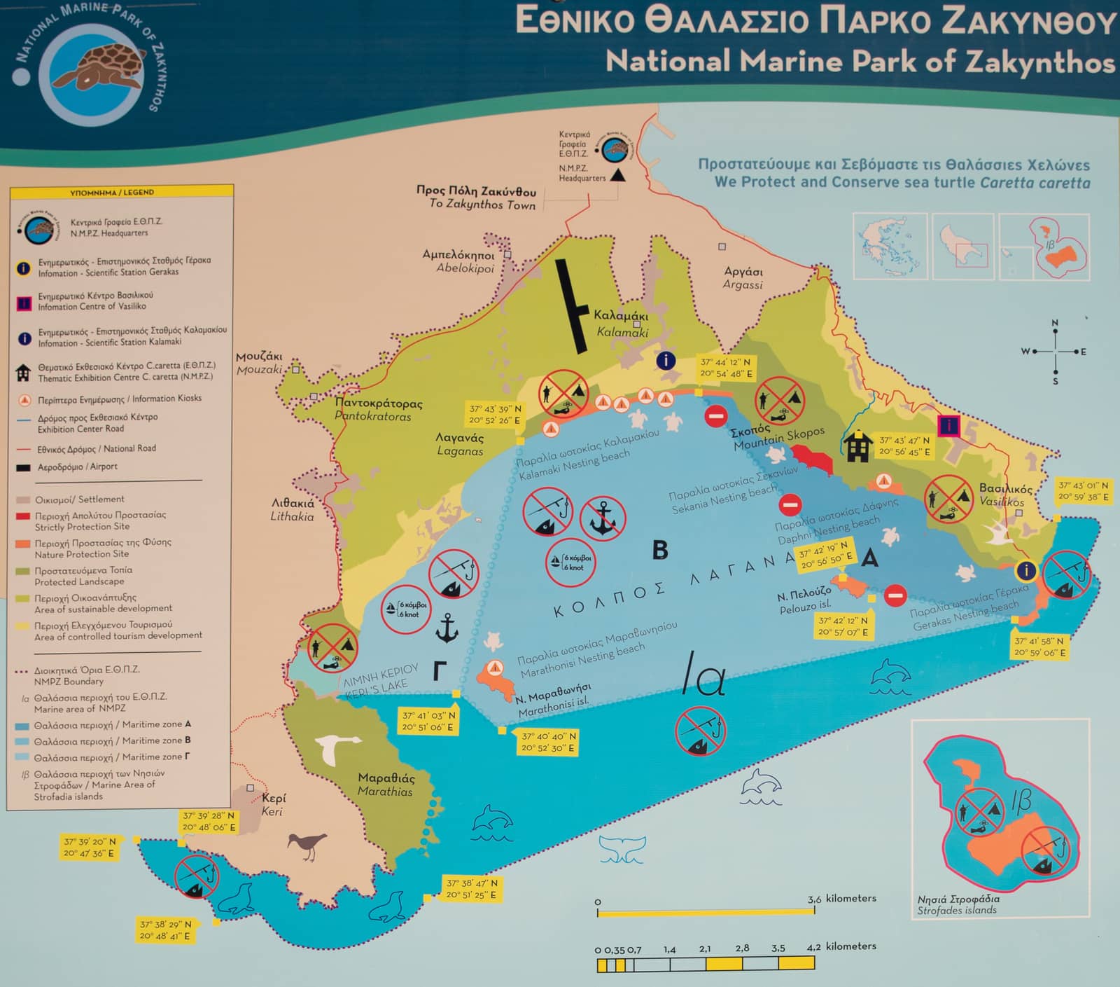
National Marine Park of Zakynthos
The National Marine Park of Zakynthos - Εθνικό Θαλάσσιο Πάρκο Ζακύνθου envelops both southern capes of zakynthos and the bay of Lagana: NMP-ZAK, aiming to protect endangered species such as sea turtles, monk seals and posidonia as well as their habitats.
During 1 May – 31 October:
- Zone A: no vessel may enter or moor / anchor; marked by circular yellow buoys separated by 75 m; no fishing.
- Zone B: vessels may enter but maximum speed is 6 knots; no mooring / anchoring; there are 3 lighted buoys:
- south of Marathonisi
- near Cape Geraki
- and in between these two
- Zone C / Γ: conical shaped buoys spaced 150 m; maximum speed is 6 knots; fishing allowed.
- Sostis port: the eastern basin usually has some free berths;
- Keri port: also cramped with local fisher/tripper boats, best to anchor outside the breakwater or in the bay between these ports.
The reefs to the north and west of Marathonisi are treacherous.
- In the wider NMPZ area you should travel at low speed to avoid colliding with turtles; no spear fishing is allowed. Note, that the inhospitable Strofades isles 25 NM to the south Lat Long are also a protected Marine Park.
Lamentably, the beaches where turtles lay their eggs are invaded by immense amounts of sun bathing tourists during the day, while in the evening the ubiquitous loud bars produce enough light polution to desorientate the turtles, although there are turtle conservation efforts.
Not surprisingly, we have seen more – and larger – Caretta caretta in the Northern Sporades and in Monemvasia.
To appreciate Zakynthos in its entirety, aim to sail in April or earlier, which also means less “humans”…
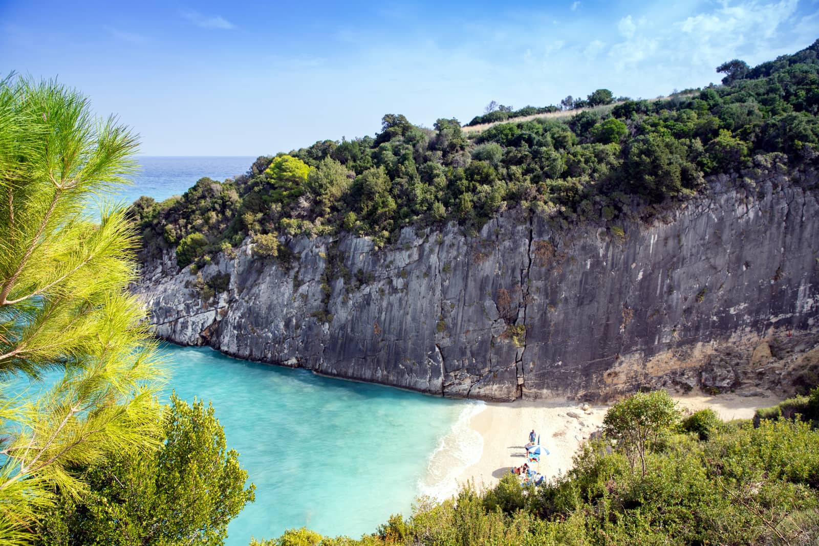
Vromis • Porto Vromi
Pórto Vrómi - Πόρτο Βρώμη (Vroma in GWP) is one of the safer anchorages on the island especially if you find yourself attached to a buoy; sheltered in pleasant surroundings; anchor in 10 – 15 m. Halfway in there is the Stamatis cave, and outside the inlet you can explore even more sea caves north of Giannaki rock.
Solid holding in sand / weed / rocks / chains / discarded-ropes, etc so vital to use a tripline; the mostly shallow quays are largely claimed by tripper boats (towards Navagio obviously) and fishermen.
Otherwise plenty of opportunities to take a line to the rocky shore. Moreover, the locals are very friendly and are willing to lend you a mooring buoy. Actually, at least 3 buoys seem intended for visiting yachts (the white one in the middle? or the 2 yellow buoys?), prices vary between €40 and €50 per night.
The bay is overrun by at motorboat rental company and the seabed is totally fouled with discarded tackle and nets.
The anchorages in Porto Vromis are unsuitable in south-westerlies and during the night katabatic gusts can sweep down the hills. The passage between Ag Ioannis island and Giannaki rock is ~75 m wide, stay in the middle and steer a SSE or NNW course.
The island of Agios Ioannis to the right, in the distance.
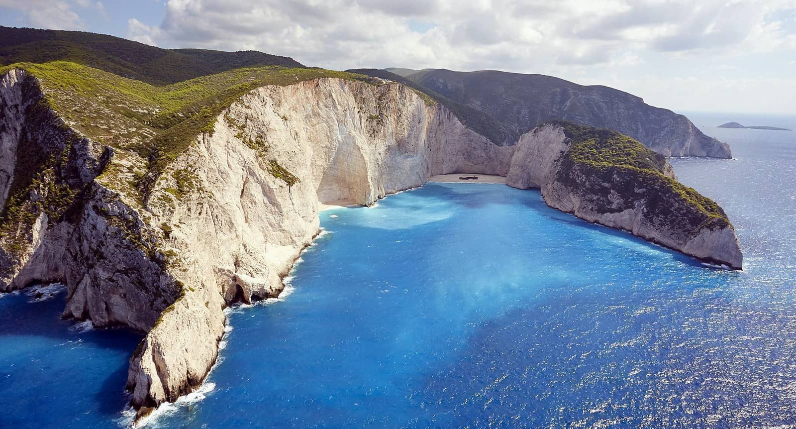
Navagio
Navagío - Ναυαγίο bay and beach became a famous icon for the Ionian islands when on 2 October 1980 the MV Panagiotis – a freightliner – ran aground here during stormy weather and bad visibility.
Shortly after, the original name of the bay “Agios Georgios” was replaced by “Navagio”, meaning Shipwreck in Greek.
It is a fair weather anchorage; best to leave within 15 minutes after the prevailing wind picks up, which can increase pronto.
Agios Nikolaos
Ágios Nikólaos - Άγιος Νικόλαος, sometimes called Skinari, is a lovely inlet and port guarded by its own homonymous islet. A partly artificial reef north of St Nikolaos / Skinari islet is marked by a red buoy. There are two anchorages suitable in NW – NE winds below the islet Lat Long and Lat Long.
 The bay itself is open to the NE – ENE winds, but also in the prevailing north-westerlies you can expect strong gusts to sweep through the valleys in the late afternoon and evening. SE winds render the bay untenable.
The seabed rises quickly and once the anchor is properly dug in – while using as much chain as possible – the high! quay and roughly triangular mole offer excellent berths. The mole is also frequented by ferries and tripper boats transporting tourists to the Blue caves further north at Cape Skinari, the north cape of Zante. The embankment at Ag Nikolaos screams “cement”, but the decor is charming nonetheless. Here is the actual quayside where most yachts will go stern-to.
Note, that the GWP gives an outdated and shallower chartlet of the port.
There are an increasing amount of guest buoys operated by friendly and helpful Kostas +30 69 79 94 32 54 from the Kostas family-run “La Storia” taverna, were you are invited to spend some money, also showers and laundry (no dryer) free of charge.
We were very happy with these two tavernas: “Madrakia” and “To Nisi”. Showers next to the Mooring cafe; supermarket well-stocked.
Makris Gialos
The underrecognized bay of Makrís Gialós - Μακρύς γυαλός is open to the northerlies and easterlies, but otherwise delightful anchorage Lat Long in terrific turquoise water.
The passage between the shore and Kápari (Míkro) islet is safe, although the headlands have reefs extending east: ideally approach from the north-east.
Closest to the beach there is perfect holding and you can take a line to the shore: superb sandy bottom. Further out in 6 to 8 m the seabed is sand, stones and rocks.
Several smaller caves to seek out, as well as “To Petrino” taverna; sometimes rolling conditions; Marakis supermarket to the north.
Xigia
Xígia - Ξύγκια is a minuscule mephitic anchorage Lat Long with a circumscribed beach in crystal clear waters under bright green pine trees.
The area (including the open beaches further south) is a “natural sulphor spa”, so you will have to endure the noxious sulphorous smells; there are various grottos in the vicinity. Take the dinghy around the verdant cape to visit the “White cave” Lat Long great snorkeling.
Imray and Garmin fail to show the islets + rocks, west of the beach and opposite the cliff face, whereas C-Map and OpenSeaMap show the correct situation.
Furthermore, the winter storms cause the sand in the bay to shift, so depths could vary by as much as 2 m compared to last season.
Secondly, there is solid anchoring in (Xígia) Pelagáki - (Ξύγκια) Πελαγάκι bay which is immediately south of the white cave. Good taverna “Xigia” up the hill. Several underwater vents and sulfur springs along the shore.
Alikanas
Alikanás - Αλικανάς is an open bay with meagre shelter: the berths inside the port are reserved for local (fishing) boats. The fecund valley is dominated by tourist resorts, the long beach by squadrons of parasols.
Note, that the even shallower port of Kavos - Κάβος is equally inutile…
Also see Greek chart terms.
Sea caves
Although there is a plethora of sea caves (e.g. see Vromis and Xigia); two stand out: