Argolic Gulf sailing holidays
The Argolic Gulf - Αργολικός Κόλπος is bordered by two mountainous regions except at the head of the gulf where the mountains give way dramatically. The wide valley visible is the Argolida: the fabled Argolid plain whose praises were sung in antiquity by Homer and others.
The shore is generally barren (interspersed with fertile valleys) and drops sheer into the sea, yielding numerous anchorages close to the shoreline.
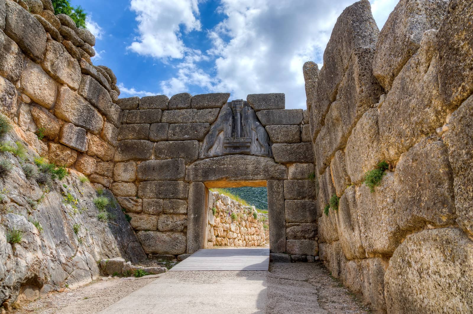
Mycenae – like the cities of Argos and Tiryns – is a mandatory visit by taxi or bus from Nafplio port. The ancient town of Mycenae was the capital of the great Helladic civilization between about 1650 and 1100 BCE.
- All Greek islands
- Argolic – Saronic overview
- Argolic gulf
- Spetses island
- Hydra gulf
- Poros island
- Aegina island
- Saronic gulf – Athens
- Alimos – Athens
- Sailing itineraries Argolic & Saronic gulfs
Its position was strategically placed to block the natural land route to the Argolic gulf. Though the Mycenaeans built a vast and wealthy empire, the Mycenaean period came to an abrupt – and unexplained – end around 1000 BCE.
Other places, Leonidion, Poulithra, Astros, Kaidhari and the island of Spetses make the Argolic Gulf a popular yacht charter area, which is just a couple of days sailing from Athens • Alimos.
The prevailing winds in the Argolic follow the east Peloponesian coastline:
southeasterly winds north of Ieraka,
however northeasterly winds in the Ieraka ‐ Monemvasia ‐ Cape Malea stretch.
British Admiralty Chart 1031
Ports Argolic Gulf
Peloponese east coast
From SW to NE, videlicet clockwise ↻

Ports / anchorages are clickable . signifies a highly recommended venue,
and a truly must-see venue; see other icons.
Velanidia
Just 5 NM north of Cape Maleas is the (fishing) port of Velanidia - Βελανιδιά, which was extended in 2018. Go alongside or stern-to under the pier Lat Long Rocks and reefs, mostly uncharted; hazardous approach, see Garmin; nearest reef has a beacon guiding you in (not indicated on most charts); ugly shoreline; delightful Poseidon / Neptune Restaurant; 15 min. walk to the authentic Greek village of Velanidia under steep cliffs: café and tiny grocery store.
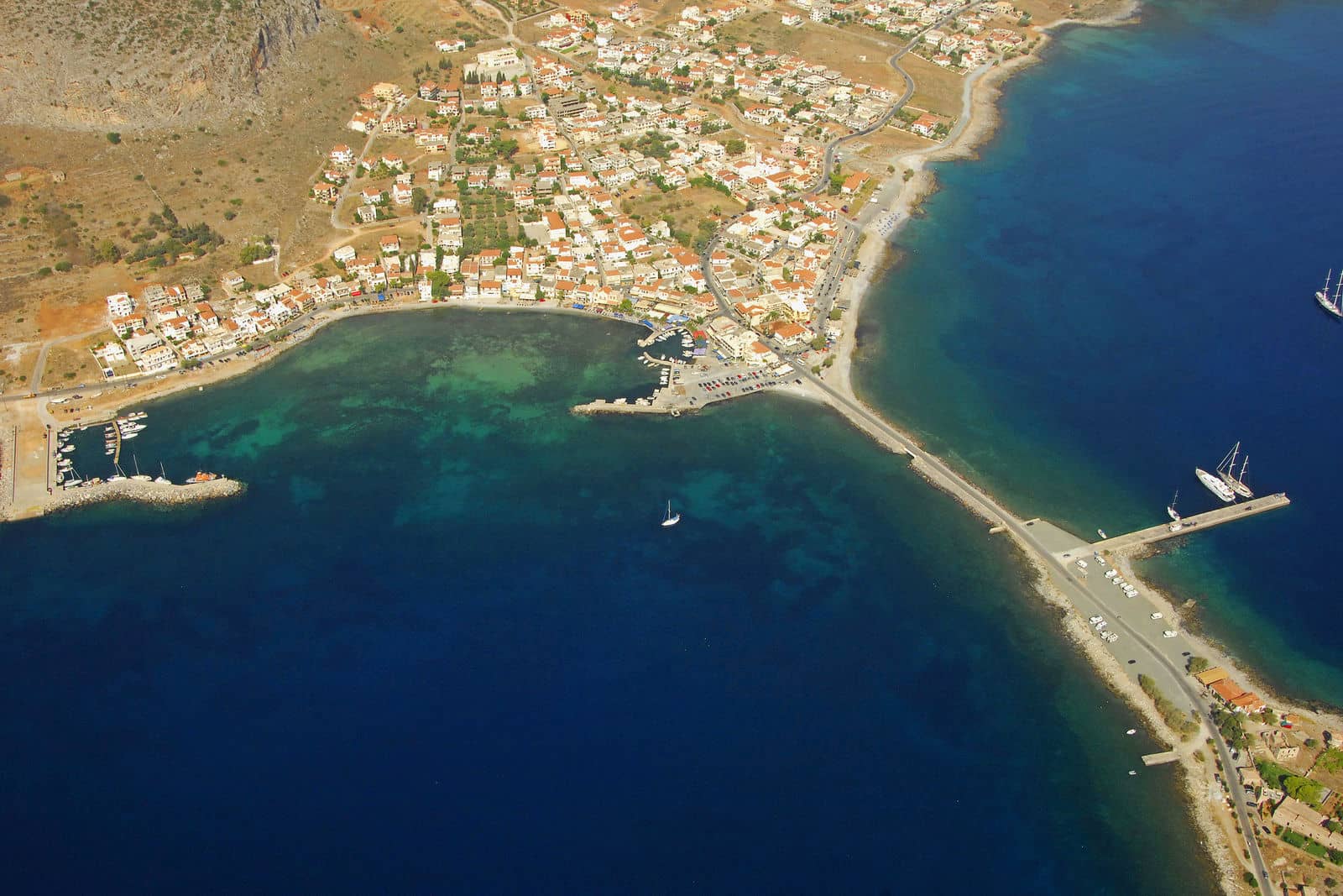
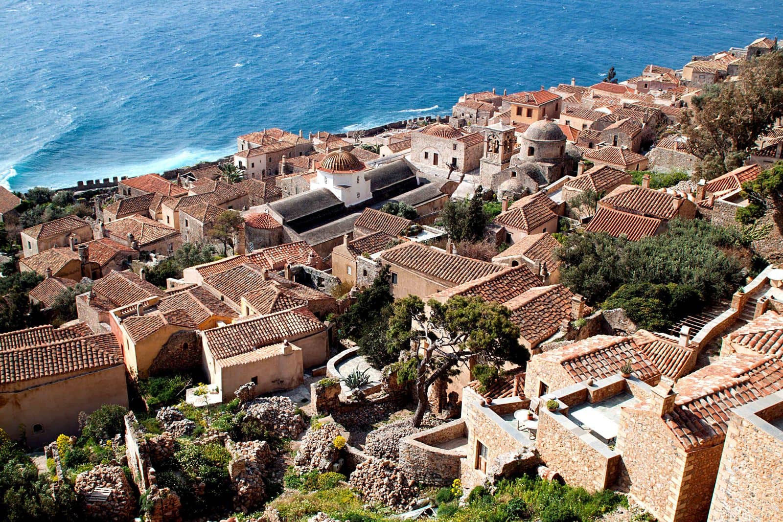
Monemvasia
Seismic activity broke Monemvasia - Μονεμβασία away from the Peloponnese in 375 CE. Nowadays this magnificent island is connected again to the village of Gefira - Γέφυρα via a slender causeway.
On the rock the medieval hamlet has come to live again with cozy restaurants and shops. From downtown you can climb the slippery walled & zigzagged stairs to the citadel; and higher still, the spiritual ascent to the Ayia Sofia Church, perched on the cliff's balcony, is an absolute must.
There are several suitable coves 3 NM to the north, notably Palaia Monemvasia which is a superb anchorage: surprisingly sheltered and within walking distance of Epidauros Limira, founded by citizens of Epidavros in the Saronic Gulf.
Explore the walled citadel and temples of Asclepius, Aphrodite and Athena. The port was known to the ancients as “the harbour of Zeus the Saviour”; drop anchor within 50 meters of the visible wreck in a depth of 5 – 8 m.
To the south the marina also offers allround shelter and gives direct access to the fortified Byzantine / Venetian village on Monemvassia. Inside the marina you can moor alongside the outer breakwater, or go stern-to the north side of the mole; very strong NE winds can cause a swell. For a berth contact Mateo from Restaurant “Ματθαίος” that overlooks the fishing port before arriving, tel: +30 695 720 06 86, he is the unofficial harbour master.
Fishermen feed the giant turtles, so several Caretta caretta can be seen swimming slowly around the harbour. Water taps only closer to the shore.
The local winds – in summertime and without a Meltemi – will rotate as follows:
from dawn till 10:00 or 11:00 a light NE wind blows;
from noon till afternoon there is a SE wind;
from the evening till midnight there blows a slight SW wind;
after which it remains calm until sunrise, yet we have experienced isolated nightly katabatic gusts from the NW!

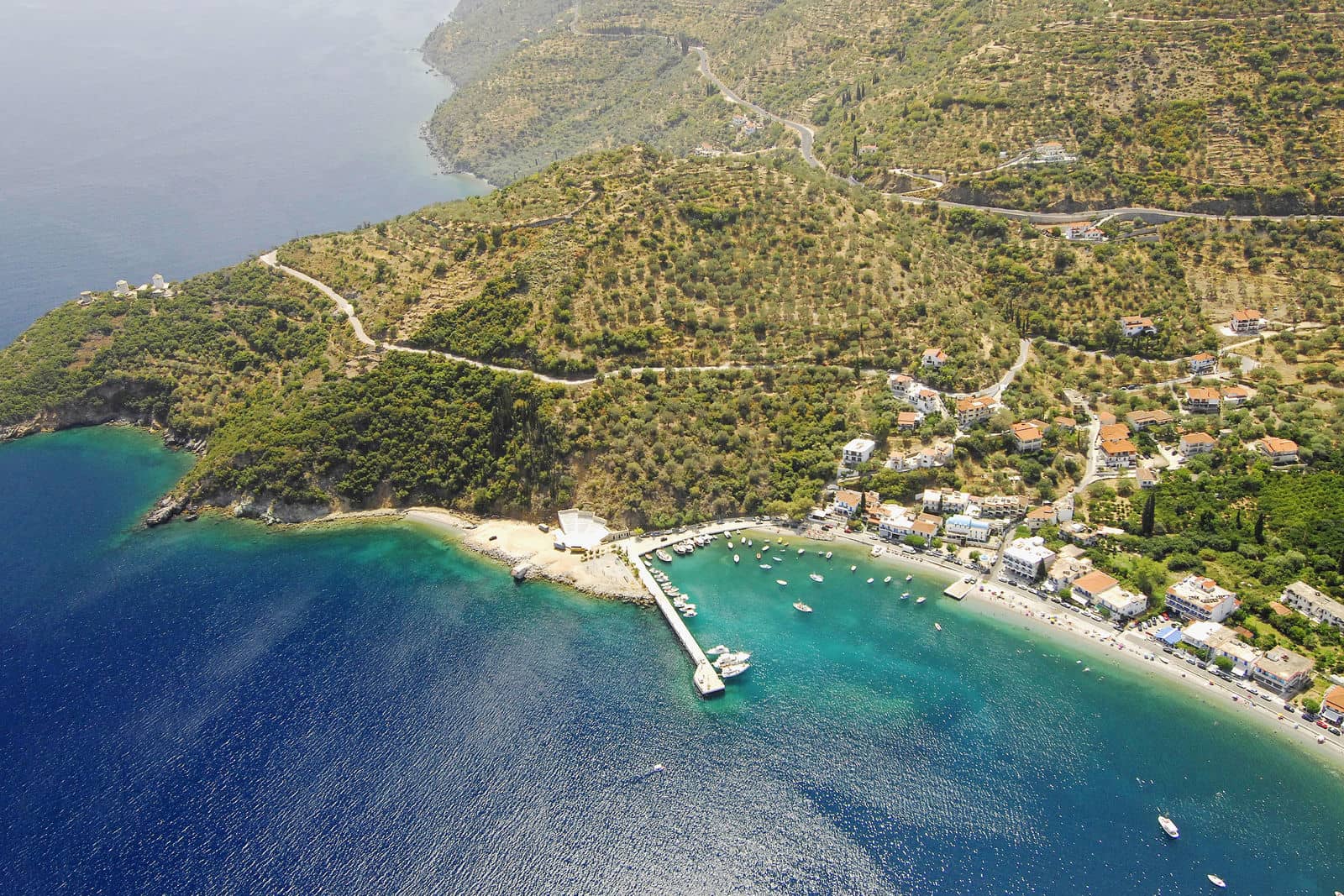
Ieraka port
Ierakas - Γέρακας / Λιμήν Ιέρακα, which is located some 20 NM south of Leonidhion, can be reached through a narrow entrance (rebound seas in strong northerlies) between high scenic cliffs.

Up the north entrance a ruined acropolis can be found of possible Mycenaean origin of the city Zarax.
Moor bows-to the boulevard with tavernas or drop anchor in the west in the proximity of the lagoon (3 – 4 m in mud).
Due to its isolation this little village is blissfully unspoiled. Rare strong SE winds will make it untenable; bad holding in places; in westerlies go alongside the easternmost quay at or next to the disused ferry quay.
The actual ancient (6th to 5th c. BCE) village of Gerakas is NW of the port; a new road connects the port with Monemvasia (10 min. drive).
Visit the cave – by dinghy – on the south cliffs, roughly opposite the acropolis, near the 8 meter mark (in southerlies also a pleasant anchorage).
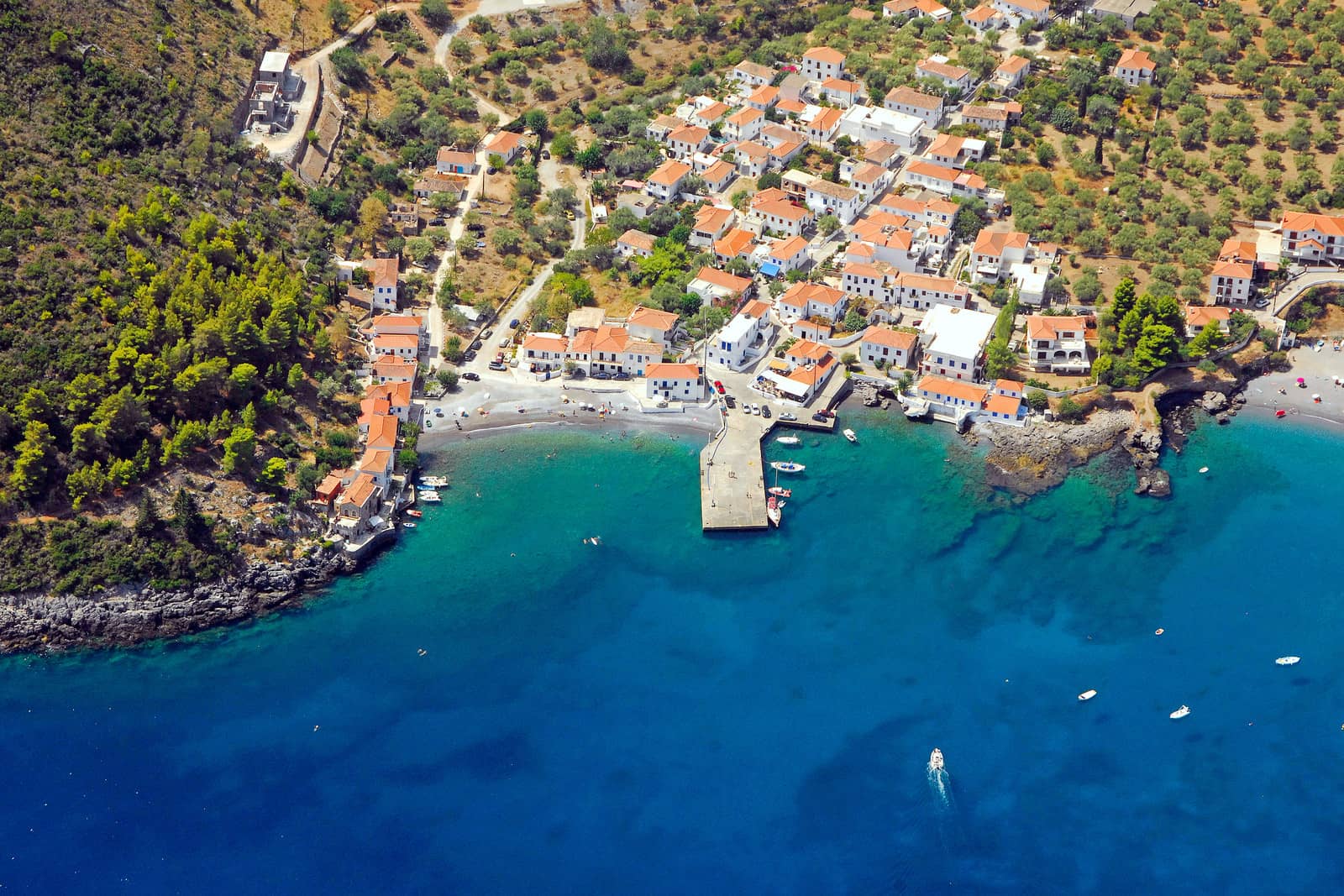
Kyparissi port
Kyparissi - Κυπαρίσσι is an authentic Greek village, mostly untouched, only in 1970 it gained road access, and a very appealing anchorage / port.
Anchor or go stern-to at the St George Chapel behind cape Nisaki. . In northerlies – even in Meltemi conditions – go stern-to the quay in the north cove; seafood at Cavo Kortia restaurant! In southerlies the pier in the village can be used; seafood at Ploes. The ferries no longer serve this bay: you can moor everywhere; the whole bight can be disturbed by (heavy) groundswell.
In the steep limestone mountainsides – and therefore a popular rock climbing destination – you can see traces of a Byzantine fortress.
Leonidion port
Plaka is the seaport of Leonidhion: the city (Leonidion - Λεωνίδιο) which is built amidst the fertile estuary below the impressive Parnon mountain range.
Due to supporting blocks the pier has shallow parts (15 m); Well sheltered except for the SE Sirocco that blows mid winter to early spring; The Meltemi blows due north in the summer months; Inside the basin there is a current from fresh water flowing south; use plenty of scope but mind the old sunken mooring chain near the beach area.
The regional Tsakonian language is of interest since it still contains ancient Doric roots and local architectural important buildings are preserved.
The citadel and pelasgian walls show that Leonidio is one of the oldest naval town in Greece, see Pelasgians.
Visit the spectacular Elona Monastery (35 km from Tyros, 17 km from Plaka).
Sampateki port
Sampateki - Σαμπατική is a tiny, lush and often overlooked venue close to Leonidio. An approach from N – E would involve sailing close to several unsurveyed reefs, best to keep over 350 meters out and arrive on a 280° course or higher. There is usually room for a couple of yachts at the southermost part of the quay or otherwise nearer the extremity; mind the rocks and old-fashioned & discarded anchor on the seabed near the light. The anchor chain that fouls the shallower part is well marked with 3 buoys.
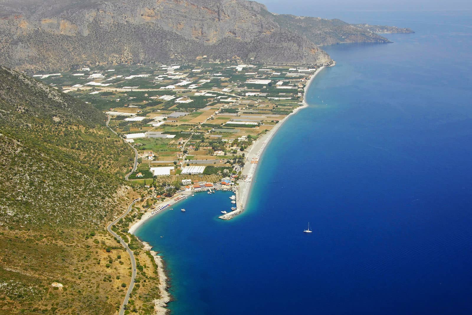
Tyros port
Tyros - Τυρός bay and village are verdant and attractive, with a long curved pebbled beach and excellent seafood restaurants (psarotavernas) and ditto bars. There are remains of an antique walled settlement near the port. Furthermore, you can enjoy a marvellous 40 minutes hike to Kastro hill (panorama and pre-historic wall).
Good holding but the anchor needs plenty of scope due to the inclined seabed. The prevailing winds are easterlies or westerlies.
Paralio Astros port
Astros - Άστρος is a bit of a personal frustration ; either the port is full or recent work (new docks) meant that we got turned away. However, the village of Astros (Astrous) is enchanting, built on subtle hills around a sandy bay.

A Frankish medieval castle on top of the hill provides a panoramic view over the gulf. Approximately 4 km from the village is the 12th c. Moni Loukous, a large nunnery with wonderful frescoes. The town of Astros is 14 km west and holds an Archaeological Museum and the villa of Herodes Atticus: a cornucopian time capsule.
Go stern-to or bows-to the SE larger mole, poor holding in places, strong north-west winds/gusts can blow down the mountains. Meanwhile, in the shallower part of the basin, additional docks for local boats were added not shown on the chart.
Nafplio port
Nafplio - Ναύπλιο is a historical rich naval city continuously inhabited since the 3rd millenium BCE. According to mythology the town of Nafplion, Nauplion, Nauplio… was named after King Navplius, son of Poseidon.
A fifth generation was also called Navplius and his son Palamedes – one of the Greek leaders in the Trojan War – was falsely accused of treason by Odysseus and subsequently excecuted. Palamedes partly created the Greek alphabet from Phoenician. Moreover, he is said to be the inventor of several standarisations of weights/measures and coins, the game of dice, navigation beacons as well as the division of time into Hours, Days, Months.
From the secluded port of Nafplio – either by bus or scooter – you “must” visit the ancient archaeological sites of Argos, Mycenae and Tiryns!
Furthermore, the local Archaeological Museum (with exhibits from the Franchthi Cave) in the central square of Nafplio, the charming old town, as well as the Palamidi fortress: the finest specimen of Venetian fortifications in Greece.
Enter the port well south of the Bourtzi - Μπούρτζι castle islet on a course of 90°. The central quay offers the best moorings especially in westerlies, ask the harbour master for a berth; VHF 12,18. During the summer months the land breeze (NW 20:00 – 06:00) follows the sea breeze (SE 11:00 – 22:00). A “marina” is scheduled in the north-east of the port basin.
The steady dredging of the port was still ungoing pre-COVID, which didn't affect the situation much since yachts were very welcome. During our visit in July 2022 there was no dredging in progress, plus we sighted several Caretta caretta in the basin. Note that marina plans have stalled.
Pelasgians
The name Pelasgians was used by classical Greek writers to refer either to the ancestors of the Greeks, or to all the inhabitants of Greece before the emergence or arrival of the Minoans and Mycenaeans, more…
Tolo port
Tolo - Τολό is a former fishing community where the delightful surroundings and ditto beach have become the new business model. A more clamorous kind of tourist, though, can spoil the anchorage near the water sports area, while the port (area) is lovelier and offers excellent allround shelter. The water level rises with S – W winds and waves created by speedboats might prevent you from going alongside.
Tolo bay is mentioned in Homer's Illiad as one of the bases of the fleets that took part in the Trojan War.

Koiladhia port
Kilada or Koilada - Κοιλάδα is a relaxing fishing village with sumptuous seafood to enjoy. Local boats fill up most of the harbour; go stern-to the north side of the longest mole near the light; the ferry actually uses the smaller southernmost mole.
A submerged Early Neolithic (4000 – 2800 BCE) settlement has been found locally (1 hm2 below 1 – 3 meters of water) and the ancient town of Masis (once situated at Kilada town) still flaunts a standing defence tower. The Franchthi Cave at the opposite side of the bay was first occupied as early as 38 thousand years ago.
See chart symbols for the meaning of e.g. ![]()
Various anchorages
Again, from west to east, videlicet clockwise ↻
 Well south of Monemvasia is the stunning Kastania cave; visit via Kamili bay anchorage Lat Long.
This is Laconia, a former administrative region of Greece, of which Sparta is the capital. The word “laconic” – to speak in a blunt, concise way – is derived from the name of this region, a reference to the ancient Spartans who were renowned for their verbal austerity and blunt, often pithy remarks.
Around Cape Malea, and across from Elafonisos is Pavlopetri.- Between Poulithra and Kyparissi is the well-known yet quiet beach and bay of Fokianou or Fokianos. In northerly winds this anchorage is very well protected, anchor on sand in 8 – 12 m close to the beach in the NNW corner Lat Long. Some of the swimming demarcation are quite deep, in 8 metres.
- While Poulithra doesn't have the charm of nearby Leonidion, there is a safe and engaging alternative directly east of Poulithra's (fishing) port in Ayios Georgios bay. Care is needed for the stretch of reefs at Cape Ayios Georgios. Anchor to the north or go stern-to at the little Church which was erected by a grateful fisherman Lat Long.
- A 2 km walk south of Nafplio is the bay of Karathonas: beach, bars and tavernas in a lovely setting Lat Long.
- The bay of Kaidhari / Drepano, at Vivari village offers allround shelter; a Venetian castle stands guard over the fjord-like entrance; the pier is usually filled with local boats. Anchor nearby in 6-10 meters Lat Long. The 10+ mooring buoys are reserved for locals, but can sometimes be used by visiting boats.
- The anchorage behind Korakonisia / Korakas (midway between Koilada and Porto Cheli). The area is not well charted mind the various reefs and rocks Lat Long.