Greek holiday
Weather
The warm holiday weather is found in Greece from mid-April till the end of October with temperatures like 18° C to 31° C in the sailing areas.A local feature called the Meltemi is a dry katabatic wind which blows from the north-west between May and September. The dry hot summers are interrupted by rainy winters. Temperatures increase from west to east, while annual precipitation increases from east to west.
Specific climatological data (sun hours, water temperatures, humidity and wind directions and speeds) can be found on our Greek climate page.
- Forecast page:
Information about how to obtain (marine) weather forecasts as well as today's weather (synoptic charts, water temps., maps etc etc). - Meltemi page:
A local feature called the Meltemi is a dry katabatic wind, which occasionally blows from the north between May and September. - Greek climate page:
Temperatures increase from west to east, while precipitation increases from east to west. Specific climatologically data and maps like: sun hours, water temperatures, humidity and wind directions and speeds.
If you wish to charter a yacht please go to my Yacht Charter page.
Otherwise, select a region below or use the logo
to navigate through Greece.
| Regions | Islands/Areas | |
| Ionian | Corfu, Anti-Paxos, Paxos, Lefkas, Kefallinia, Ithaka, Zakynthos |
| Dodecanese | Patmos, Arki, Lipso, Leros, Kalymnos, Kos, Nisyros, Tilos, Symi, Rhodes |
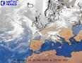
| Real time satelite image: |
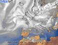
Forecast weather image: |
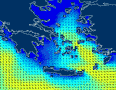
Wave height prediction: |
 |
 |
 |
Satellite pictures
A view from the East out of the space shuttle (not a real satellite, though). This picture shows a full N-S cross-section of the Mediterranean Sea. Left is the African continent and the Libian peninsula. In the middle is Kreta and at the right most of the Cycladic islands can be seen. The horseshoe shape is the old vulcano of Thira or Santorini.
The tailpiece of the shuttle is seen right over the island Kea with just below it the island Kithnos. Across the Saronic gulf, Nisos Aegina can be seen.
A view from the South-West of the Southern cyclades and all the dodecanese islands. The larger islands left of the vulcano are Paros and Naxos. At the top the proximity of Turkey is clearly visible; the dodecanese islands are nevertheless mostly Greek. Right/above is Rhodos.
Again, the dodecanese islands, but now viewed from Turkey (from North-Earth). At the left Rhodos can be seen.
This view covers our last cruise in September 2000, when we sailed from Paros to Rhodos in a fortnight. At the top right Tinos and Andros can be seen (seemingly attached). More to the left Kea, Kythnos, siros and so on...
A view from the Peleponnese penisula toward Istanbul which can be seen at the top middle.
I saved
the best image for last. It features the entire east coast of Greece, centered on the Peleponnese penisula. The Ionian islands are on the left.
Ancient Greece
The Greek history
comprises different archeological eras as well as interesting topics and this site deals with the everyday live of the old Greek, their economics and religions.
On many islands archeological hot-spots can be found like temples and thermae. Just click on the charts.
The Perseus Project also uses charts to show where art and culture can be found. Furthermore, the history atlas and a compilation of famous Greek writings (with English translations :-) are a must see. An interactive map of the Old World depicts archeological sites which can easily be reached by sailing the islands of the cyclades and dodecanese.
A great Mythology website , providing many illustrations, poems and links with respect to the Greek mythology.
![]()
![]()
![]()
![]()
![]()
![]()
![]()
![]()
![]()
![]()
![]()