Sailing maps
Greece

Home Nav. course Sailing Greece Turkish Coasts Yacht charter Gulets                          

Nautical maps of Greece

Below you will find a compilation nautical maps of the various sailing areas of Greece which are published throughout my website. You might also like the interactive road and political maps of Greece. All these maps are copyrighted and should not be used for navigational purposes.
Map of Cyclades - Greece Map of Dodecanese - Greece Map of the Argolic and Saronic Gulfs in Greece
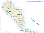
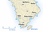
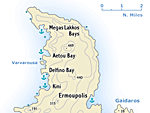
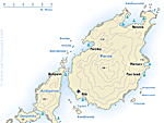
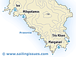
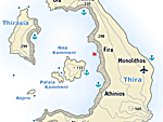
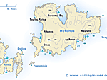
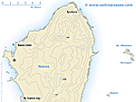
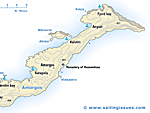
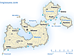
Nautical map of the Cyclades: Myconos, Ios, Paros, Naxos, Santorini 
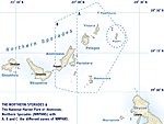
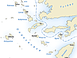
Nautical map of the Dodecanese: Patmos, Kos, Symi, Rhodes 
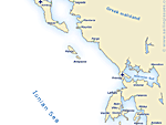
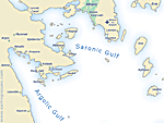
Nautical map of the Argolic & Saronic Gulfs: Aegina, Poros, Hydra, Spetses
Map of the Ionian Sea in western Greece Map of the Northern Sporades Nautical chart of the Argolic Gulf.
Nautical map of the Ionian Islands: Corfu, Lefkas, Kefalonia and Zakynthos Nautical map of the Northern Sporades: Skiathos, Skopelos and Alonissos Nautical map of the Argolic Gulf and Spetses


Maps Cyclades Greece

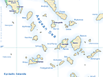
Although most Cycladic islands are rather bare with few trees, they form one of the best and most beautiful sailing areas in the world. It is truely an inspiring place where you can sail in the ancient calderas of Milos (extinct volcano) or Santorini (still active volcano), but also feel the ancient history and visit archaeological sites on nearly all the islands. Moreover, the steep cliffs of Amorgos, the beautiful bays of Sifnos, the Chora on Folegandros, etc. etc. are all must-see places.
Nautical chart of Tinos and Andros in the Cyclades Nautical chart of Sifnos Island Nautical map of Syros Island
Sailing map of Tinos Andros Sailing map of Sifnos Sailing map of Syros
Nautical map of Paros and Anti-Paros Chart of Ios Island Sailing map of Santorini
Sailing map of Paros Sailing map of Ios Sailing map of Thira Santorini
Map of Mykonos Myconos and Delos Dilos Nautical chart of Naxos and the little Cyclades south of Naxos Map of Amorgos - one of the most beautiful islands in the Aegean Sea
Sailing map of Mykonos Delos Sailing map of Naxos Sailing map of Amorgos
Map of Milos Melos and surrounding islands Sailing chart of Kea Tzia Island Map of the stunning island of Kythnos Kithnos
Sailing map of Milos Sailing map of Kea Sailing map of Kythnos


Related pages:
Clickable maps of Greece.
Our logbook from Athens to Santorini - has more maps.
Road and political maps of Greece.
Map of the Corinth Canal.
Map of Lavrion Port.
Sailing maps of other popular islands like:
Astypalea, Skiathos, Skopelos, Spetses, Aegina, Folegandros.

Nautical maps by Imray (Tetra Charts).


E-mail:
E-mail:
Books·charts Sitemap| A-Z Contact RSS| Charterguide
Diederik Willemsen | E-mail me
Site map | A-Z index | Register

 RSS XML Feed | | Level AA conformance icon, W3C-WAI Web Content Accessibility Guidelines 1.0 | |