Coastal
NAVIGATION
![]()
![]()
Positions
The earth can be regarded as a spherical object which revolves around the sun in 365.25 days. Since we're dealing with a 3-dimensional shape we need coordinates of a different form than the usual x- and y-axes. Though adding an extra z-axes would make sense for submarines, we will most likely be found on the surface of this sphere while using another system of coordinates. This system covers our planet with imaginary lines called Parallels & Meridians, see figure 1. 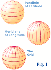 All these lines together provide the grid which enables us to describe any position in Longitudes and Latitudes. Where to place the divide between the North and South hemispheres was obvious: the equator. But the division of the Eastern and Western hemispheres was the source of much political turmoil. As you probably know, Greenwich (Great Britain) won, placing for example The Netherlands on the Eastern and Ireland on the Western Hemisphere. It takes the earth 24 hours for a full rotation of 360 degrees. Thus, every hour we rotate 15 degrees longtitude, see figure 2. Also 12:00 Greenwich Mean Time (GMT) is 24:00 Local time at the other side of the planet: 180 E or 180 W: the Date Line. Crossing this meridian changes not only the hour but also the date.
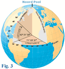
The North pole has a latitude of 90 degrees N and the South Pole 90° S. The Meridians cover twice this angle up to a max of 180°. 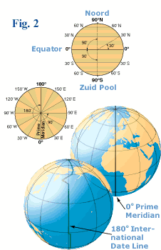 So, Meridians converge at the poles, whereas Parallels run parallel to each other (nomen est omen) and never meet. All Meridians and the Equator (the biggest parallel) form great circles, but the other parallels form small circles. A great circle divides the earth in two exact halves.
In figure 3 the position of Boston is shown using latitude and longitude. The position is 42° 21' 30" N , 71° 03' 37" W [degrees, minutes, seconds]. Most sailors will actually use 42° 21',5 N , 71° 03',6 W as a notation for this position. On small scaled charts we want to be accurate within one minute or one nautical mile. On larger scaled charts the accuracy is more likely to be within a tenth of a mile (a cable).
So, Meridians converge at the poles, whereas Parallels run parallel to each other (nomen est omen) and never meet. All Meridians and the Equator (the biggest parallel) form great circles, but the other parallels form small circles. A great circle divides the earth in two exact halves.
In figure 3 the position of Boston is shown using latitude and longitude. The position is 42° 21' 30" N , 71° 03' 37" W [degrees, minutes, seconds]. Most sailors will actually use 42° 21',5 N , 71° 03',6 W as a notation for this position. On small scaled charts we want to be accurate within one minute or one nautical mile. On larger scaled charts the accuracy is more likely to be within a tenth of a mile (a cable).
If the earth were a perfect sphere all meridians would be as long as the equator. Unfortunately, it is not and therefore we will use the equator length as the circumference of our earth. This circle is divided into 360 degrees, or 360° x 60' = 21.600' minutes. One minute of this great circle is exactly the same as one nautical mile, or to put it shortly: 1 nm = 1'.
 The length of the equator is 40.000 odd kilometers. Hence, one nautical mile is around 1.852 meters long. With all this information we are now able to describe any position in latitudes and longitudes. Moreover, we can state the distance between two of those positions using nautical miles or minutes. All we need now is a proper way to define speed. For that, sailors use knots, the number of nautical miles an hour.
A little History
Mariners during the 15th century relied on charts called "portolans" to assist them on their voyages. 'Portolan' comes from the Italian word 'portolani', which were medieval pilot books. The portolans contained maps of coastlines, locations of harbors, river mouths, and man-made features visible from the sea.
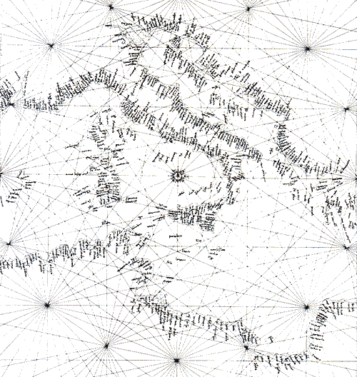 They were a compilation of centuries of seafarer observations. As sailors' skills improved and the use of the compass was more widespread, portolans improved in accuracy. Also Columbus used these portolans on his journeys. Portuguese chartmakers added the meridian line, a point useful for latitude sailing as well as for navigating solely by compass. A geographic feature could now be located through the use of its distance in degrees of latitude from a ship's point of departure. Note that the use of latitude and longitude was understood since the time of Ptolemy
![]() , the second century CE.
, the second century CE.
During the fifteenth century Portugal led the European world in sea exploration. The golden age of discovery for Portugal lasted almost a century until the Dutch eventually seized their trade routes from them.
As we move to the next chapter of this course we enter the sixteenth century when the Mercator chart was invented.
Overview
Parallels: Circles parallel to the equator, ranging from 0° to 90° N or S. Only the equator is a great circle.
Meridians: half-Circles conversing at the poles, ranging from 0° to 180° E or W. Each pair of meridians forms a great circle.
Prime Meridian: 0° or the Greenwich meridian which divides the Western and Eastern hemispheres.
Great Circle: The intersection of a sphere and a plane through its center.
Small Circle: The intersection of a sphere that does not pass though its center.
Time Zones: By convention 24 zones, each 15° longitude wide. Hence, noon at greenwich gives midnight at 180° E.
GMT: Greenwich Mean Time or UTC or Zulu, and is the time in Greenwich. Antonym: Local time. Berlin's local time = GMT + 1.
Date Line: The meridian which extents from the prime meridian. Here, not only the hour changes, but also the date.
Latitude: Position property defined by the number of degrees North or South of the equator, varies from 0° to 90°.
Longitude: Position property defined by the number of degrees East or West of the prime meridian, varies from 0° to 180°.
Position: Latitudes first and Longitudes second. For example: Nijmegen (NED) = 51° 50',1 N , 05° 52',0 E.
Nautical Mile: One nm is one minute (') on the chart. 1' equals 1.852 meters.
Knots: Nautical miles per hour.