Meltemi
![]()
![]()
![]()
The Etesian winds
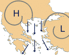
The Meltemi wind was known by the old Greek as the Etesian northern winds, and results from a high pressure system (>1025) laying over the Balkan/Hungary area and a relatively low pressure (<1010) system over Turkey. Although this katabatic wind can bring about harsh sailing conditions it also provides cooling, low humidity and good visibility. Furthermore, it can be characterized as one of the few Mediterranean winds that do not necessarily die out at the end of the day and can easily last more than three to six days. See our climate page for Greek weather statistics.
The onset is the monsoonal effect of the summer season that leads to the development of an
intense heat trough over southern Asia extending westward over the Anatolian plateau.
Higher pressure dominates over the relatively cooler surface of the
Mediterranean Sea, and settled, dry weather persists.
Northerly winds prevail along the Greek coast during the
winter also, but only those northerly winds occurring between May and
November are considered Etesian. The pressure gradients necessary to drive the
Meltemi result from a combination of:
- The monsoonal effect during the summer that leads to a low pressure trough over Turkey. Etesian winds flow from a high pressure ridge over the Balkans toward the trough. During a strong Etesian, the trough may extend relatively far to the west and beyond Rhodes. It may also form a closed low, resulting in almost calm winds at Rhodes.
- Synoptic conditions leading to anti-cyclogenesis over the Balkans.
- A jet-effect wind increase caused by channelling of the wind between islands and mountain valleys. These effects tend to render wind reports from certain locations unrepresentative. In the lee of Crete, katabatic flow off the mountains generates gusty winds similar to the Föhn of the Alps. The mountain valleys tend to channel the flow which increases the wind velocity.
 The surface flow is generally divergent in an Etesian situation, and
the weather is generally thought to be dry with clear skies. However,
this is mostly true only during July and August
when scattered altocumulus appear a day before an Etesian,
and the only other clouds are orographic types that may form on the lee
side of islands in stronger Etesian winds.
The surface flow is generally divergent in an Etesian situation, and
the weather is generally thought to be dry with clear skies. However,
this is mostly true only during July and August
when scattered altocumulus appear a day before an Etesian,
and the only other clouds are orographic types that may form on the lee
side of islands in stronger Etesian winds.
The Meltemi occurs mainly during the summer season (June - September with 70%), but also in May and October one may frequently experience this dry wind. One should anticipate its maximum during July and August.
Usually the wind starts in the early afternoon reaching 4-5 Bft and dies out at sun set. However, not uncommonly it reaches 6-7 Bft during the day, perseveres during the night and blows 6-7 Bft again the next day; a pattern which can easily be repeated over many days, sometimes even up to ten days.
If during this period sailing to windward can not be avoided, it can be very wise to lift anchor at dawn and to cover as many miles as possible before the wind starts.
Due to the katabatic nature of the meltemi one can experience strong fall winds on the leeward side of the islands, notorious are Kea (we did survive though), Euboa, Tinos and Andros, Pholegandros, Kos, Serifos, Amorgos and Sifnos. An orographic cloud to leeward of the mountain spells danger.
When the wind encounters very high cliffs on the North shore of an island, a calm -extending several miles off shore- can be expected. Good examples are Amorgos, Paros and Naxos.
In the wide corridor between de dodecaneses and cycladen the Meltemi blows undisturbed over 100 miles. Within six hours of a 30 knot wind, the waves can reach heights over three meters. The adverse currents make these waves steeper, which can be seriously dangerous for yachts smaller than 10 meter.
Expect funnelling winds, which can make certain straits dangerous to pass because of currents and higher wind velocities. Classical areas are: between Andros and Euboa (currents up to 6 knots!); between Ikaria and Samos till the Phournoi-archipelago; Between Paros and Naxos; North side of Amorgos; West side of Karpathos. Sometimes South of both Kea and Kithnos.
Tell-tales for your own Meltemi 24-36 hour prediction:
- Higher predicted atmospheric pressure over the Balkan/Northern Aegean.
- A sudden drop in humidity (first morning without dew on deck).
- Scattered little altocumulus clouds one day in advance.
- A clear improvement of visibility combined with a raise in atmospheric pressure (4 hPa within 12 hours).
A little history
Nowadays any soft and gentle breeze is referred to as a zephyr. Theophrastus, a 4th-century BCE scholar who left us with a complete accounting of the winds of Greece wrote: "Zephyros, the west wind, is the most gentle of all the winds and it blows in the afternoon and towards the land, and is cold,"...