Coastal
NAVIGATION
Tides
The tide is the vertical rise and fall of the sea level surface caused primarily by the change in gravitational attraction of the moon, and to a lesser extent the sun.
As the earth spins on its axis the centrifugal force results in slightly deeper water near the equator opposed to shallower water at the poles. In fact it causes a flow from the poles to the equator.
The earth is also in orbit around the sun (one turn in one year) creating not only another centrifugal force but also a gravitational interaction. These two yield a bulge on the night site (centrifugal) and bulge on the day site (gravitational) both of them moving as the world turns. Therefore, a certain place on this world will experience two high and two low tides each day.
With these forces alone, we would not have spring tides and neap tides. Spring tides have higher high tides and lower low tides whereas neap tides have lower high tides and higher low tides. Hence, the range (difference in water level between high and low tide) is much larger in a spring tide than in a low tide.
 |
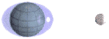
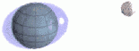
| This animation shows how the tide chances during the lunar cycle. When the sun, moon and earth are aligned: spring tide. When at right angles the forces are not aligned: neap tide. The time between spring and neap is approximately 7 days. |
It is the combined effect of the sun and moon that creates spring and neap tides. In the animation the gravitational forces of both the sun and the moon are taken into account. When aligned with the earth they combine their attraction and otherwise they counteract their attraction. The sun is located in the corner right below, far outside this picture (note the eclipse) while the moon is revolving round the earth. One full circle corresponds to one lunar cycle (about 28 days).
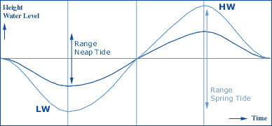
The figure below shows the ideal sinusoids of both spring and neap tides. Vertically the water height is shown versus horizontally the time. Ideally, the time between a low and a successive high is somewhat more than 6 hours.
So, tidal movements are intrinsically periodical, resulting in a Tidal day of 24 hours and 50 minutes containing one tidal cycle, namely two highs and two lows. This basic pattern may be distorted by the effects of landmasses, constrained waterways, friction, the Coriolis effect, or other factors. Hence, predictions are possible and we expect the next day the high tide to come about 50 minutes later.
However, a closer look at the orbit of the moon reveals that the moon is not always in the equatorial plane, resulting in three types of tides:
- Semi-diurnal tide:
 Featuring two highs and two lows each day, with minimal variation in the height of successive high or low waters. This type is more likely to occur when the moon is over the equator.
 - Diurnal tide:
 Only a single high and a single low during each tidal day; successive high and low waters do not vary by a great deal. This tends to occur in certain areas when the moon is at its furthest from the equator.
 - Mixed tide: Characterized by wide variations in heights of successive high and low waters, and by longer tidal cycles than those of the semi-diurnal cycle. These tides also tend to occur as the moon moves furthest north or south of the equator.
Chart Datums
The depths and heights in the chart need a plane of reference: the Chart Datum (see interactive figure below). Depths are usually described with respect to low water reference planes (yielding lower charted depths, which are safer) and heights are shown with respect to high water reference planes (again, yielding lower vertical clearances on the chart, which are safer). As such, the chance that the observed depth or vertical clearance beneath a bridge is smaller than the charted depth or height is rather small.
Some Chart Datums and their abbreviations:
- MHWS : Mean High Water Spring
- HW : High Water
- MHWN : Mean High Water Neap
- ML : Mean Level
- MLWN : Mean Low Water Neap
- MLWS : Mean Low Water Spring
- LAT : Low Astronomical Tide
Overview
Tide: The vertical rise and fall of the surface of a body of water caused primarily by the differences in gravitational attraction of the moon, and to a lesser extent the sun, upon different parts of the earth when the positions of the moon and sun change with respect to the earth.
Spring Tide: The tidal effect of the sun and the moon acting in concert twice a month, when the sun, earth and moon are all in a straight line (full moon or new moon). The range of tide is larger than average.
Neap Tide: This opposite effect occurs when the moon is at right angles to the earth-sun line (first or last quarter). The range of tide is smaller than average.
Range: The vertical difference between the high and low tide water levels during one tidal cycle.
Tidal Day: 24 hours and 50 minutes. The moon orbits the earth once earth month, and the earth rotates (in the same direction as the moon's orbit) on its axis once every 24 hours.
Tidal Cycle: A successive high and low tide.
Semi-diurnal Tide: The most common tidal pattern, featuring two highs and two lows each day, with minimal variation in the height of successive high or low waters.
Diurnal Tide: Only a single high and a single low during each tidal day; successive high and low waters do not vary by a great deal. Gulf of Mexico, Java Sea and in the Tonkin Gulf.
Mixed Tide: Characterized by wide variation in heights of successive high and low waters, and by longer tide cycles than those of the semidiurnal cycle. U.S. Pacific coast and many Pacific islands.
Chart Datum or Tidal reference planes: These fictitious planes are used as the sounding datum for the tidal heights.
Drying Height: Clearance in meters (or feet in old charts) above the chart datum.
Charted Depth: Clearance in meters (or feet in old charts) below the chart datum.
Observed Depth: Height of tide + charted depth: the actual depth in meters.
Height of light: The height of light above the bottom of its structure.
Elevation: The height of the light above the chart datum.
Rule of Twelve: Assuming a tidal curve to be a perfect sinusoid with a period of 12 hours. The height changes over the full range in the six hours between HW and LW with the following fractions during each respective hour: 1/12 2/12 3/12 3/12 2/12 1/12.
Rule of Seven: The change from spring range to neap range can be assumed linear, each day the range changes with 1/7th of difference between the spring and neap ranges.
Hence, the daily change in range = (spring range - neap range)/7.